


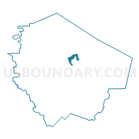
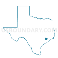
Voting District 1001, Fort Bend County, Texas
About
Outline

Summary
| Unique Area Identifier | 673101 |
| Name | Voting District 1001 |
| County | Fort Bend County |
| State | Texas |
| Area (square miles) | 3.94 |
| Land Area (square miles) | 3.46 |
| Water Area (square miles) | 0.48 |
| % of Land Area | 87.89 |
| % of Water Area | 12.11 |
| Latitude of the Internal Point | 29.58195950 |
| Longtitude of the Internal Point | -95.74026200 |
Maps

Graphs
Select a template below for downloading or customizing gragh for Voting District 1001, Fort Bend County, Texas


Neighbors
Neighoring Voting District (by Name) Neighboring Voting District on the Map
- Voting District 1040, Fort Bend County, TX
- Voting District 1067, Fort Bend County, TX
- Voting District 1073, Fort Bend County, TX
- Voting District 1074, Fort Bend County, TX
- Voting District 1076, Fort Bend County, TX
- Voting District 1103, Fort Bend County, TX
- Voting District 3041, Fort Bend County, TX
- Voting District 3063, Fort Bend County, TX
- Voting District 4124, Fort Bend County, TX
Top 10 Neighboring County Subdivision (by Population) Neighboring County Subdivision on the Map
- Sugar Land CCD, Fort Bend County, TX (248,350)
- Fulshear-Simonton CCD, Fort Bend County, TX (102,849)
- Rosenberg-Richmond CCD, Fort Bend County, TX (86,436)
Top 10 Neighboring Place (by Population) Neighboring Place on the Map
- Rosenberg city, TX (30,618)
- Pecan Grove CDP, TX (15,963)
- New Territory CDP, TX (15,186)
- Richmond city, TX (11,679)
Top 10 Neighboring Unified School District (by Population) Neighboring Unified School District on the Map
- Fort Bend Independent School District, TX (348,526)
- Lamar Consolidated Independent School District, TX (122,887)
Top 10 Neighboring State Legislative District Lower Chamber (by Population) Neighboring State Legislative District Lower Chamber on the Map
Top 10 Neighboring State Legislative District Upper Chamber (by Population) Neighboring State Legislative District Upper Chamber on the Map
Top 10 Neighboring 111th Congressional District (by Population) Neighboring 111th Congressional District on the Map
Top 10 Neighboring Census Tract (by Population) Neighboring Census Tract on the Map
- Census Tract 6734, Fort Bend County, TX (14,932)
- Census Tract 6747, Fort Bend County, TX (11,165)
- Census Tract 6755, Fort Bend County, TX (11,151)
- Census Tract 6738, Fort Bend County, TX (9,342)
- Census Tract 6751, Fort Bend County, TX (9,099)
- Census Tract 6736, Fort Bend County, TX (6,966)
- Census Tract 6748, Fort Bend County, TX (5,645)
- Census Tract 6749, Fort Bend County, TX (5,543)
- Census Tract 6746.04, Fort Bend County, TX (4,607)